On August 21st at about 10 in the morning, the moon cast its shadow across northern Oregon. In the weeks leading up to this solar eclipse, several unfortunate events caused the closure of virtually all designated wilderness areas along the PCT in the path of totality. (The excuse was fire danger, but it was most likely due to the hysteria surrounding the apocalyptic amount of visitors Oregon was predicting for the eclipse.) We had originally planned to be somewhere on the PCT, but in a short amount of time we needed to come up with an alternative. With the help of Google Maps, we randomly settled on the Strawberry Mountain Wilderness. Continue reading “Strawberry Mountain Wilderness Loop”
Tag: volcanic
Castle Peak
The hike up Castle Peak is a short and steep. We previously snowshoed to the summit, but we headed back out there last week to check out the snow-free trail. Continue reading “Castle Peak”
Kings Creek Falls Trail
A waterfall hike might not be the first thing that comes to mind in the midst of a severe drought. Nevertheless, after hiking the Lassen Peak Trail, we decided to check out the nearby Kings Creek Falls and upper cascades. We were pleasantly surprised by the amount of water in Kings Creek. Continue reading “Kings Creek Falls Trail”
Hiking Lassen Peak
Lassen Peak (10,457′) is the southernmost active volcano in the Cascade Range. It last erupted 100 years ago in 1915. Despite spewing volcanic ash as far as 200 miles away, this most recent eruption is considered very small. Fortunately for us, volcanoes don’t explode without warning and the USGS now monitors Lassen very closely. The trail to the top of the peak is one of the more popular hikes in the park. Most of the trail is above tree-line and the views are stunning. Continue reading “Hiking Lassen Peak”
Red Lake Peak
On this day in 1844, John C. Fremont and Charles Preuss summited Red Lake Peak. It wasn’t a particularly impressive climb, or circumstance; it was however the first documentation of an identifiable peak climbed in the Sierra. Surely many people climbed peaks before this, but since this blog is a place where we document climbs of peaks (and other hikes), the 171st anniversary of the first documented peak climb seems significant. In any case, repeating this climb seemed like the best possible way to spend a Valentine’s Day. Continue reading “Red Lake Peak”
Black Butte
Black Butte is a hike up a small volcanic peak with great views of Mt. Shasta. It’s a little over 5 miles round trip and 1850 feet of elevation gain.
We drove up to Bend, Oregon last week to visit family and spend a few days skiing. Not much snow in California this winter, so Mount Bachelor was worth the long trek! On our drive up, we passed under the shadow of Black Butte – a prominent peak right next to I-5 in the Mount Shasta area. It looks relatively small next to Mount Shasta, but it is actually 6334-ft and looms steeply above the freeway. As we drove toward it, we both exclaimed: “What is that peak? Can we climb it?!” Turns out, there’s an easy trail that goes to the top. Continue reading “Black Butte”
Hiking the Sutter Buttes (North Butte Ascent)
This hike must be guided by the Sutter Buttes Regional Land Trust. The route goes straight up the butte without any real switchbacks – 1200 feet of elevation gain in under three miles round trip, with the most strenuous part 1000 feet up in half a mile.
Basics: Access to the Sutter Buttes is extremely limited. Much of the land is comprised of privately owned ranches. The Sutter Buttes Regional Land Trust (formerly the Middle Mountain Foundation) provides guided hikes into the area. This is really the only way for the general public to access the Sutter Buttes. After looking at the scheduled hikes, I naturally picked one of the most difficult ones: the North Butte Summit Ascent.
The hike itself is not actually that long – about 3 miles roundtrip from the parking area to the summit and back. We added an extra mile or two by taking a detour on the way out. It’s difficult because there is no actual trail. The route climbs over 1000-ft at a very steep grade. Despite the short distance, this hike took at least 5 hours. Continue reading “Hiking the Sutter Buttes (North Butte Ascent)”
Mount Saint Helens
Basics: This is a challenging winter climb to the summit of an active volcano in the Cascade Range. The weather is unpredictable, but on a clear day the views are well worth the effort. The hike from this particular route is approximately 12 miles roundtrip with an elevation gain of over 5700 feet. There is one other trail (with less elevation gain) to the summit, but it can only be accessed when the road to Climber’s Bivouac is free of snow. Parking is free but permits are required anywhere above 4800 ft. Continue reading “Mount Saint Helens”
Ape Cave in Washington
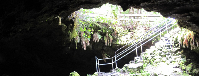
Basics: This is a short hike through a lava tube at Mount Saint Helens in Gifford Pinchot National Forest (Washington state). The cave is very dark – two light sources per person are recommended. There’s not terribly much to see, but it’s a unique and interesting experience. Including the return hike, the trip is under 3 miles. A parking permit is required and can be purchased at the parking lot. During the summer, lanterns can be rented at the kiosk near the entrance. Continue reading “Ape Cave in Washington”