Mt Tamalpais via the Steep Ravine Trail

If you wanted to, you could drive almost to the top of Mt. Tamalpias. But if you want to really climb Mt. Tam, then start from the ocean. This hike leaves from Stinson Beach and climbs the Steep Ravine trail up to East Peak, then loops back on the north side. The grand total is over 16 miles, and a few thousand feet of elevation gain.

00

Basics:  This hike climbs from Stinson Beach to the East Peak of Mt Tamalpais.  It’s a long one – we hiked it as a loop totaling over 16 miles round trip.  We reached the top via the Steep Ravine Trail, Matt Davis Trail and Old Railroad Grade road.  We returned on the International Trail, Northside Trail, Bay Area Ridge Trail and Matt Davis Trail (among others).  Mt Tam has an amazingly large and well developed network of trails and roads.  There are many options.  Everything is well-signed, but unless you know where you are going, bring a map! Continue reading “Mt Tamalpais via the Steep Ravine Trail”

Hiking the Sutter Buttes (North Butte Ascent)

This hike must be guided by the Sutter Buttes Regional Land Trust. The route goes straight up the butte without any real switchbacks – 1200 feet of elevation gain in under three miles round trip, with the most strenuous part 1000 feet up in half a mile.

00

Basics: Access to the Sutter Buttes is extremely limited. Much of the land is comprised of privately owned ranches. The Sutter Buttes Regional Land Trust (formerly the Middle Mountain Foundation) provides guided hikes into the area. This is really the only way for the general public to access the Sutter Buttes. After looking at the scheduled hikes, I naturally picked one of the most difficult ones: the North Butte Summit Ascent.

The hike itself is not actually that long – about 3 miles roundtrip from the parking area to the summit and back. We added an extra mile or two by taking a detour on the way out. It’s difficult because there is no actual trail. The route climbs over 1000-ft at a very steep grade. Despite the short distance, this hike took at least 5 hours. Continue reading “Hiking the Sutter Buttes (North Butte Ascent)”

Annie’s Trail

Annie’s trail is a loop that was added to the existing Cold Canyon trail in 2012. Together, the two trails make for a 7.5 mile hike with about 2500 ft elevation gain – a moderately strenuous hike.

00
Basics: We started the new year off right with a hike along Blue Ridge near Cold Canyon. Annie’s trail is a loop that was added to the existing Cold Canyon trail in 2012. Together, the two trails make for a 7.5 mile, moderately strenuous hike. A highlight of Annie’s Trail is Annie’s Rock – a giant boulder outcropping near the top of the ridge. It’s a great spot for lunch.

The trail is still relatively new – in 2009, Tuleyome and supporters purchased Cold Canyon Headwaters, a 72-acre parcel in the upper watershed above Stebbins Cold Canyon UC Natural Reserve. Tuleyome volunteers built the 2.5 mile loop and named it Annie’s Trail. It is named after late Tuleyome board member Anne Schneider who was instrumental in helping preserve the Cold Canyon Headwaters. Continue reading “Annie’s Trail”

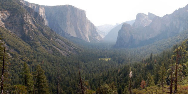
Inspiration Point, Artist Point, and the Old Wawona Road

ArtistPt

We had big plans for hiking in Yosemite (on the order of twenty miles or so), but the summer heat defeated those plans. With little more than wet rocks in place of raging waterfalls, I wanted to go on a hike away from the crowds, and with a little bit of history. This hike fit that bill perfectly, even if it was a bit ad-lib. Continue reading “Inspiration Point, Artist Point, and the Old Wawona Road”

Garrapata State Park Loop

01

Basics: This 4+ mile loop trail in Garrapata SP goes from coastal chaparral to grassy hills with epic views to dense redwood forest.  Parts of the trail are really steep, but the ocean views and springtime wildflowers are enough to keep anyone going.  We added a side trip to Doud Peak, making this a 6 or 7 mile hike.  Doud Peak was not worth the extra effort, but more on that later.  This hike would be nice any time of year, but it’s especially pretty in the spring when the plants are still somewhat green and the wildflowers are blooming.  It’s also a great workout if you are in the area and want to hike something that won’t take all day. Continue reading “Garrapata State Park Loop”

Stebbins Cold Canyon Reserve

Basics: This moderately strenuous 5-mile loop begins in Stebbins Cold Canyon Reserve (a UC Davis Nature Reserve) and climbs up onto an adjacent BLM trail with impressive views of Lake Berryessa. All of this is part of Putah Creek State Wildlife Area comprised of 670 acres of varied terrain just downstream of the Monticello dam, where Cold Creek enters Putah Creek. This is a great year-round hike, but it can be a little brutal in the summer heat. This hike is extremely popular – especially with college students – so if you are looking for solitude, get there early.

Continue reading “Stebbins Cold Canyon Reserve”

Blue Ridge – Fiske Peak Loop Trail

Basics: This 17+ mile loop on BLM land travels along Blue Ridge, then descends and winds through Fiske Creek’s riparian canyon. This trail would be difficult on a hot summer day, but it is a great winter hike with expansive views. Continue reading “Blue Ridge – Fiske Peak Loop Trail”

Mount Olympia and North Peak – Diablo SP

Basics: This 10+ mile hike takes you up 3000 feet to the top of both Mt Olympia and North Peak in Mount Diablo State Park. The network of trails ranges from wide fire roads to steep and narrow single track footpaths. This trip provides excellent views and makes for a great winter hike. The trail can be accessed at the end of Regency Drive in the town of Clayton – parking at this locations is free. The trail can also be reached from Mitchell Canyon Interpretive Center – parking is $6 and this option adds a mile or two to the trip. A good map of the park is essential. Trail maps can be purchased at the Mitchell Canyon visitor’s center or at REI. Continue reading “Mount Olympia and North Peak – Diablo SP”

Mount Diablo – Summit Hike

Basics: This is a 14 mile hike to the top of Mt Diablo from Mitchell Canyon (on the northern side of the mountain).  There are many trails and many different options for hiking to the top, but all of them will require over 3000 ft of climbing.  Our particular route also took us to the top of Eagle Peak (elev 2369′).  Two peaks in one long hike!  The trail begins at Mitchell Canyon Interpretive Center – located at the end of Mitchell Canyon Road in the city of Clayton.  Parking is $6. Continue reading “Mount Diablo – Summit Hike”