Basics: This moderately strenuous 5-mile loop begins in Stebbins Cold Canyon Reserve (a UC Davis Nature Reserve) and climbs up onto an adjacent BLM trail with impressive views of Lake Berryessa. All of this is part of Putah Creek State Wildlife Area comprised of 670 acres of varied terrain just downstream of the Monticello dam, where Cold Creek enters Putah Creek. This is a great year-round hike, but it can be a little brutal in the summer heat. This hike is extremely popular – especially with college students – so if you are looking for solitude, get there early.

Directions to Trailhead: From the town of Winters, take Hwy 128 West towards Lake Berryessa. Shortly after leaving town, the road will begin to follow Putah Creek. Eventually you will pass through Canyon Creek Resort – a private campground and RV park. Monticello Dam will be on your right. Continue just a little further up the road and pull in to the dirt parking area on the right (after the bridge and before the hairpin turn). [Google Maps link to Parking Area]
[map kml=”http://www.norcalhiker.com/maps/Stebbins_Canyon.kml” download=”no” elevation=”yes” style=”width:100%; height:400px” /]Note: GPS based distance is approximate. Download gpx of this route. Download kml of this route.
Trail Description: This trail is a loop, so it could be hiked in any direction, but we’ve always hiked clockwise. The trail begins directly across the road from the dirt lot. Listen for cars, look both ways, then RUN! People drive crazy fast on this road.

The trail begins flat and meandering along the stream. In the spring this is a nice place to view wildflowers. You can enjoy a lot of riparian vegetation along the creek. In about a mile you cross the stream and from there the trail begins to climb gently through a dark oak forest. This continues for some time until you reach a junction where the path continues left (flat) to the old homestead site, or continues to the right, straight up the steep hill. The homestead isn’t far and it’s neat if you’re into that sort of thing. When you’re done with the detour you should be mentally prepared for the climb ahead of you. The trail is steep all the way to the ridge as it switches back and forth. There are also some stairs on the steepest parts. It’s interesting how quickly the environment changes from a dense oak woodland to a dry open chaparral.

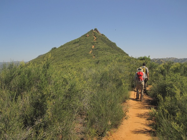
When you reach the ridge you can rejoice, temporarily. A trail continues along the ridge to the left, but you will probably want to turn right to continue onwards along the main loop (and back toward your car). As I said, rejoice temporarily. You will climb three separate peaks along this ridge before you begin to really descend. The ridge is the most scenic part of this trail – expansive views, lake views, rock hopping and steep climbs/descents. What more could you want in a short hike?


When the ridge trail finally descends to the right, you will find yourself on a nicely graded trail through sparse and grand valley oak trees. Wow, that’s four completely different plant communities – so much NorCal packed into one hike. (For those of you not paying attention, those four are: riparian, dense live oak forest, chaparral, and grassy Valley oak woodland.) There is poison oak along much of the trail, but if you keep your hands to yourself you should be safe. This hike is hard enough to challenge seasoned hikers, short enough to be done by beginners with a strong will, and close enough to be a regular place to check in on at all times of the year.
More Info: This hike is also described at Yolohiker, and it’s prominently featured on the cover of 60 Hikes Within 60 Miles of Sacramento, at least the version that I have.

