Basics: Loch Leven Lakes are three very popular alpine lakes in Tahoe National Forest. The lakes are surrounded by granite and typical Sierra scenery. The hike is approximately 8 miles roundtrip. It is slightly shorter if your destination is the first of the three lakes. These lakes offer great swimming and camping – they definitely get crowded on summer weekends! Continue reading “Loch Leven Lakes”
How to Download (and use) Topo Maps
It’s important to be able to read a map if you think you are hiking somewhere that you might get lost. It’s equally important to bring the map with you on your hike. While I must say Tom Harrison makes some mighty fine plastic topo maps, they aren’t available for every possible location. So this post will hopefully point you to the info you need to plan your next hike.

Mt Tamalpais via the Steep Ravine Trail
If you wanted to, you could drive almost to the top of Mt. Tamalpias. But if you want to really climb Mt. Tam, then start from the ocean. This hike leaves from Stinson Beach and climbs the Steep Ravine trail up to East Peak, then loops back on the north side. The grand total is over 16 miles, and a few thousand feet of elevation gain.
Basics: This hike climbs from Stinson Beach to the East Peak of Mt Tamalpais. It’s a long one – we hiked it as a loop totaling over 16 miles round trip. We reached the top via the Steep Ravine Trail, Matt Davis Trail and Old Railroad Grade road. We returned on the International Trail, Northside Trail, Bay Area Ridge Trail and Matt Davis Trail (among others). Mt Tam has an amazingly large and well developed network of trails and roads. There are many options. Everything is well-signed, but unless you know where you are going, bring a map! Continue reading “Mt Tamalpais via the Steep Ravine Trail”
Black Butte
Black Butte is a hike up a small volcanic peak with great views of Mt. Shasta. It’s a little over 5 miles round trip and 1850 feet of elevation gain.
We drove up to Bend, Oregon last week to visit family and spend a few days skiing. Not much snow in California this winter, so Mount Bachelor was worth the long trek! On our drive up, we passed under the shadow of Black Butte – a prominent peak right next to I-5 in the Mount Shasta area. It looks relatively small next to Mount Shasta, but it is actually 6334-ft and looms steeply above the freeway. As we drove toward it, we both exclaimed: “What is that peak? Can we climb it?!” Turns out, there’s an easy trail that goes to the top. Continue reading “Black Butte”
Hiking the Sutter Buttes (North Butte Ascent)
This hike must be guided by the Sutter Buttes Regional Land Trust. The route goes straight up the butte without any real switchbacks – 1200 feet of elevation gain in under three miles round trip, with the most strenuous part 1000 feet up in half a mile.
Basics: Access to the Sutter Buttes is extremely limited. Much of the land is comprised of privately owned ranches. The Sutter Buttes Regional Land Trust (formerly the Middle Mountain Foundation) provides guided hikes into the area. This is really the only way for the general public to access the Sutter Buttes. After looking at the scheduled hikes, I naturally picked one of the most difficult ones: the North Butte Summit Ascent.
The hike itself is not actually that long – about 3 miles roundtrip from the parking area to the summit and back. We added an extra mile or two by taking a detour on the way out. It’s difficult because there is no actual trail. The route climbs over 1000-ft at a very steep grade. Despite the short distance, this hike took at least 5 hours. Continue reading “Hiking the Sutter Buttes (North Butte Ascent)”
Ohlone Wilderness Trail
The Ohlone Wilderness Trail connects Del Valle Regional Park (just south of Livermore) to Mission Peak Regional Preserve (in Fremont). The trail is 28 miles long with 7,100 feet of elevation gain including Rose Peak and Mission Peak.
Rose Peak, Mission Peak & 28 miles of Trail in Two Days
Basics: The Ohlone Wilderness Trail connects Del Valle Regional Park (just south of Livermore) to Mission Peak Regional Preserve (in Fremont). It passes through Ohlone Regional Wilderness and Sunol Regional Wilderness, as well as some land owned by the San Francisco Water District where you’re not allowed to leave the trail. The trail is 28 miles in length, not including short detours to campsites or to the top of Mission Peak. There are many out-and-back options for hiking in this area. A shuttle or other transportation arrangement is required to thru-hike the entire 28 miles. Continue reading “Ohlone Wilderness Trail”
Quarry Road Trail to American Canyon
The Quarry Road Trail in Auburn State Recreation Area is perfect for trail running, easy mountain biking or hiking. It’s also dog and horse friendly. The trail is six miles long, and gently climbs a few hillsides along the river.
It has finally rained in California! Not enough to save us from the drought, but at least the grass is a little less brown. The snow conditions still aren’t great (heavy, wet snow) so rather than braving the holiday weekend crowds, we decided to saunter in the foothills. The next best thing to do after some rain is to go see a waterfall! So many waterfalls in California seem to just spring up out of nowhere for a few short weeks or days each winter. This one actually has water for a decent portion of the year.
Basics: The Quarry Road Trail in Auburn State Recreation Area actually follows a portion of the Western States Trail. It’s a wide dirt path that is perfect for trail running, easy mountain biking or hiking. It’s also dog and horse friendly. The entire trail is nearly six miles from beginning to end. We extended our hike another mile by heading up the single track American Canyon Trail to some small waterfalls and a deep little hidden pool. Continue reading “Quarry Road Trail to American Canyon”
Billy’s Hill & Glascock Mountain
This 10 mile hike is located on BLM land, just across the highway from Cache Creek Regional Park. The hike starts off climbing steeply up to Billy’s Hill. If you continue all the way to Glascock Mountain it’s 10 miles and 3100 feet of elevation gain.
Basics: This 10 mile hike is located on BLM land, just across the highway from Cache Creek Regional Park. The hike starts off climbing steeply up to Billy’s Hill. After enjoying the views from there, it’s possible to continue on up two ridges (with a few steep sections) all the way over to Glascock Mountain. There is no official trail, but the path follows a combination of use trails, fire breaks and a somewhat overgrown fire road. Continue reading “Billy’s Hill & Glascock Mountain”
Annie’s Trail
Annie’s trail is a loop that was added to the existing Cold Canyon trail in 2012. Together, the two trails make for a 7.5 mile hike with about 2500 ft elevation gain – a moderately strenuous hike.
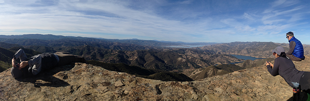
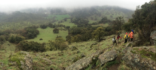
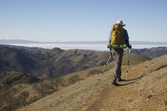
Basics: We started the new year off right with a hike along Blue Ridge near Cold Canyon. Annie’s trail is a loop that was added to the existing Cold Canyon trail in 2012. Together, the two trails make for a 7.5 mile, moderately strenuous hike. A highlight of Annie’s Trail is Annie’s Rock – a giant boulder outcropping near the top of the ridge. It’s a great spot for lunch.
The trail is still relatively new – in 2009, Tuleyome and supporters purchased Cold Canyon Headwaters, a 72-acre parcel in the upper watershed above Stebbins Cold Canyon UC Natural Reserve. Tuleyome volunteers built the 2.5 mile loop and named it Annie’s Trail. It is named after late Tuleyome board member Anne Schneider who was instrumental in helping preserve the Cold Canyon Headwaters. Continue reading “Annie’s Trail”
Martis Peak Fire Lookout
The fire lookout on Martis Peak can be reached from both Martis Peak Road and the Tahoe Rim Trail. We had a limited amount of time, so we opted to go up the paved road which is a slightly shorter route. This hike is 8 miles roundtrip, with about 1700-ft of elevation gain.
It’s been way too long since we got out and hit the trails. We had some spare time before the holidays, so we decided to head up to Tahoe for the weekend. There’s not much snow yet this year – 2013 was the driest calendar year on record (though water is usually summed by water year: Oct-Sep). California is going to have some serious water problems if we don’t get crazy amounts of rain/snow in the next couple of months. We wanted to use our snowshoes, but the road looked pretty bare so we left them in the car. (Of course the road was completely covered in snow as soon as we turned the first corner.) This hike was 8 miles roundtrip, with about 1700-ft of elevation gain. Continue reading “Martis Peak Fire Lookout”