
Sometimes great things go undiscovered for a long time. I recently discovered this awesome website that I wish I had found much earlier. CalTopo is the ulitmate topographic planning tool for all your adventures; it’s no surprise that it was made by a dedicated search and rescue team member.
It’s actually really surprising – I would think it would take a whole team of software engineers to make this site. Hopefully if more of us hikers use tools like this, there will be less calls to SAR for help. It’s your responsibility to go out with the assumption that nobody is going to save you. Be smart and plan your trip with tools like CalTopo.

The features that make me love this site are too many to delve in to with great detail, but I’ll highlight my favorites:
- Right click anywhere on the map and…
- Get the NOAA weather forecast
- Get location and elevation
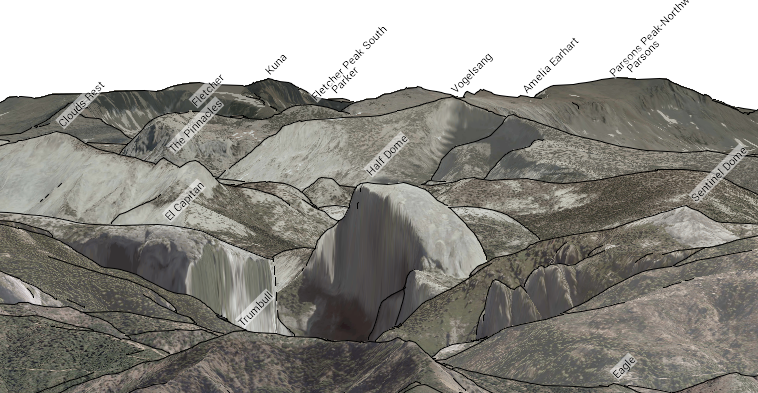
- See what the view is like from that location
- Seriously the “view from here” tool is amazing – it draws and names peaks
- Beautifully overlay topographic map or imagery
- Right click on a mountain and open a new map at that location
- It’s like having a computerized telescope on top of the mountain
- Absolutely beautiful maps:
- Support for multiple layers and transparency is unmatched in browser mapping – on par with expensive GIS software
- Rarely seen (and very nice) USFS topo
- Historic topographic maps
- Topographic lines on aerial photos
- Analysis normally only available in expensive desktop GIS software
- Slope, shaded relief, sunlight, and viewshed analysis
- Realtime USGS streamflow gages (best I’ve seen, and I’m a hydrologist)
- Draw lines, points and polygons
- Create elevation profiles for lines!
- Import and export kml/gpx files
- Current and historic fires
- View public land ownership
- Georeference your own overlay photos!
- Save, print, share, and use the maps
- Save map to modern Garmin units!
- Save maps to geoPDF for use in Avenza PDF app on your phone!
- Cache the map to your browser for offline use with CalTopo To Go
- Print beautiful 8.5×11 pdf with scale bar, north arrow, and coordinates
- Embed maps on websites
- Share hyperlink of maps
In summary CalTopo is totally badass. It gives you all of the functionality of the $150 National Geographic TOPO! software, for free (for now). I understand eventually some features may cost money, but from the way it looks now, it will be worth it. I’d gladly pay $1 per pdf map printout. If printed on Rite-in-the-Rain waterproof inkjet paper, it’s almost as good as a Tom Harrison map for a fraction of the price and available for any location. If you love CalTopo as much as I do I encourage you to check out Matt Jacobs’ blog about his site – CalTopo.Blogspot.com.
Burd told me about that site a few weeks ago. Though I mostly am not hiking anymore, beats Google and Maps (Apple) for topo detail, though with my iPod I downloaded 15’s by an app, also free but outdated maps. Unfortunately when I had to restore the device, the maps did not come back by my back-up. Life-saver when you can get a signal, but the morons would rather die than ever use cheap, modern technology!
Wow, what a great resource! Perfect timing too as I’m planning a trip into the Bucks Lake Wilderness in a couple of weeks.
I’m glad you found it helpful! Have fun out there. You might find some good stuff from the Bucks Lake Hiking Association.