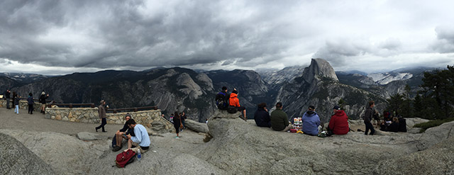
The Four Mile Trail (actually 4.8 miles) is one of Yosemite Valley’s most strenuous trails. It climbs up to Glacier Point – an ascent of nearly 3300-ft in just under five miles. After the grueling uphill slog, hikers are rewarded with unparalleled views of Half Dome and the rest of Yosemite Valley. Glacier Point can also be reached by car or shuttle, but the view feels much more rewarding when you walk. We hiked this on a rainy Saturday in late September. Though summer is over, there were still plenty of people out and about. You can’t expect much solitude on this trail, but you can look forward to a great workout and some good people watching! Continue reading “Yosemite Valley to Glacier Point: Four Mile Trail”
White Mountain Peak
At 14,252-ft, White Mountain Peak is the third tallest peak in California. It is located in the White Mountain range, east of the Sierra Nevada in Mono County. The peak is often considered California’s easiest 14er. A dirt road goes all the way to the summit. Some people reach the top on mountain bikes. The hike is a long one though – 14 miles roundtrip with approximately 2000-ft of elevation gain. Hikers are often defeated and turned back by extreme winds or the high altitude. It is by no means an easy walk. Continue reading “White Mountain Peak”
Schulman Grove Loop – Ancient Bristlecone Pine Forest
This 4 mile loop snakes through one of several bristlecone pine groves in the White Mountains of California. The bristlecones are the oldest living trees (and the oldest living anything) on earth! This trail is pretty far “out there,” but these trees are incredible and definitely worth a visit. The hike itself is at 9,500 to 10,500-ft elevation and has several hundred feet of up and down. There is a visitor center at the trailhead. There is also an option for a shorter 1 mile loop with equally spectacular views of the ancient bristlecones. Continue reading “Schulman Grove Loop – Ancient Bristlecone Pine Forest”
Mount Williamson via Shepherd Pass
There is nothing easy about climbing California’s second tallest peak. The approach is long (over 26 miles round trip) and involves climbing nearly 10,000 ft. Some super humans have day hiked this peak. We took three days to do it and it was still quite a challenge. Continue reading “Mount Williamson via Shepherd Pass”
Sierra Buttes Fire Lookout
The hike to the Sierra Buttes Fire Lookout is about 5 miles (out and back) with a climb of 1500 feet (or more if you start at a different trailhead). It’s a pretty cool destination! We went with a group of 14 people and even the non-hikers seemed to enjoy the lookout! The top (at 8587-ft) provides views down to Upper/Lower Sardine Lakes, the surrounding Sierra Buttes and many miles of Tahoe National Forest. Continue reading “Sierra Buttes Fire Lookout”
Round Top and Winnemucca Lake
Climbing to the top of Round Top is an interesting hike – it starts of very mellow/easy and gets progressively more difficult as you get closer to the summit. The final 100′ or so are considered an easy Class 3. This hike is located in the Carson Pass Management Area (part of the Mokelumne Wilderness), just south of Highway 88 near Kirkwood Mountain Resort. The beginning of the hike is crowded – many people simply hike up to Winnemucca Lake (a worthy destination in itself) – but far fewer people reach the summit of Round Top. When hiked as a loop, this trip is approximately 6.5 miles with 2000 ft of elevation gain. There are many trail signs; if one knows which general direction to head in, it’s nearly impossible to get lost.
Backpacking Tuolumne Meadows to Yosemite Valley
It’s no surprise Yosemite is one of the most visited National Parks in the country – the place is beautiful. Backpacking is a great way to get away from the crowds of Yosemite Valley. The trails are still more heavily travelled than many others in the Sierras, but the scenery is unbeatable. There are several different ways to get from Tuolumne Meadows to Yosemite Valley. Our route took us over Clouds Rest and up Half Dome. Continue reading “Backpacking Tuolumne Meadows to Yosemite Valley”
Lake Aloha via the Ralston Peak Trail
Shortly after our last failed attempt at backpacking in Desolation Wilderness, I was ready to try again. We waited a few weeks for more snow to melt, then made our reservation for Lake Aloha (Zone 33). We snagged 6 of the allotted 25 spots for this zone.
Basics: This overnight hike was about 13 miles round-trip. This distance sounds easier than it is – the Ralston trail begins by climbing 2400-ft in a few short miles. Anyone looking for an easier approach can access Lake Aloha from the Echo Lakes area. From the route described in this post, it’s possible to take short detours to climb Ralston Peak or visit several other Desolation Wilderness lakes. Continue reading “Lake Aloha via the Ralston Peak Trail”
Amazing Planning Tool: CalTopo
Sometimes great things go undiscovered for a long time. I recently discovered this awesome website that I wish I had found much earlier. CalTopo is the ulitmate topographic planning tool for all your adventures; it’s no surprise that it was made by a dedicated search and rescue team member. Continue reading “Amazing Planning Tool: CalTopo”
Lyons Creek Trail – Desolation Wilderness
Things don’t always go according to plan. I’m normally pretty good at planning stuff and I have decent luck most of the time, but every once in a while hiking does not go how I expect.
Continue reading “Lyons Creek Trail – Desolation Wilderness”