Yosemite’s North Rim

In the Footsteps of John Muir [Part II]

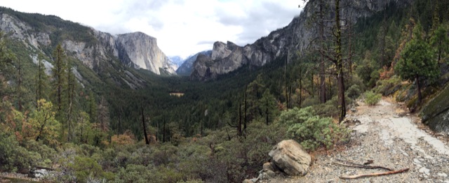
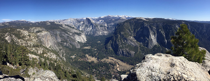
John Muir described two single day Yosemite hikes in Chapter 12 of his book The Yosemite. The chapter is titled “How Best to Spend One’s Yosemite Time.” By today’s standards, these hikes are very difficult – about 20 miles with around 5000-ft of elevation gain.  We followed his advice and completed the first recommended hike back in October 2013.  It was probably the hardest day hike we’ve ever done.  We were game for the second one. Muir’s second single day hike takes you up Yosemite Falls to Eagle Peak, over to the top of El Capitan, then back down to the Valley via the (now abandonned) Old Big Oak Flat Road Trail (OBOFRT).  Continue reading “Yosemite’s North Rim”

Snow Mountain

Last week, as I was making plans to visit the Snow Mountain Wilderness, I discovered that the vast majority of people I talked to had never heard of Snow Mountain. This is too bad because efforts are underway to create a Berryessa Snow Mountain National Monument. This would protect the land for future generations while improving coordination between the agencies who plan for fires, manage recreation and clear out invasive species and/or marijuana grow sites. There is already a lot of support for the proposed National Monument, but if more people knew about the area, there might be greater momentum behind the cause. Continue reading “Snow Mountain”

Red Lake Peak

On this day in 1844, John C. Fremont and Charles Preuss summited Red Lake Peak. It wasn’t a particularly impressive climb, or circumstance; it was however the first documentation of an identifiable peak climbed in the Sierra. Surely many people climbed peaks before this, but since this blog is a place where we document climbs of peaks (and other hikes), the 171st anniversary of the first documented peak climb seems significant.  In any case, repeating this climb seemed like the best possible way to spend a Valentine’s Day. Continue reading “Red Lake Peak”

Pleasants Ridge – Putah Creek Wildlife Area

Pleasants Ridge is one of those trails I’ve passed by and ignored on many occasions.  We are frequent visitors to the Stebbins Cold Canyon Loop, but we rarely branch out to any of the other trails in the area. The Pleasants Ridge hike starts at the same trailhead – just off of Highway 128 in the Putah Creek Wildlife Area. Roundtrip distance is about 2 or 3 miles, depending on how far you want to go. We followed the trail to the end of the ridge. The last half mile or so is very overgrown and does not see a lot of visitors. Continue reading “Pleasants Ridge – Putah Creek Wildlife Area”

Pyramid Peak via Rocky Canyon

We’ve attempted and failed to hike Pyramid Peak more times than I’d like to admit. Poor planning, late starts and crappy weather have all thwarted past attempts. Our friend Nolan has had a similar experience. After climbing far more challenging peaks, we (jokingly) began to wonder if we’d ever make it to the top of “the elusive Pyramid Peak.”

Finally, this past weekend we made it happen. The weather was looking to be perfect. We chose the most direct route – Rocky Canyon from Highway 50. We were determined to finally knock this one off our list. Continue reading “Pyramid Peak via Rocky Canyon”

Briones Regional Park

00

If you’re looking for a wild and rugged place to hike, Briones Regional Park is not it (unless you consider cows to be “wildlife”).  The park does offer a substantial network of trails  within the heart of Contra Costa County.  Rolling grassy hills provide spectacular views of Mount Diablo, the Carquinez Strait and the surrounding suburbs.  Briones is one of the many parks managed by the East Bay Regional Park District.  At 6000+ acres, it’s easy to hike or run 10+ miles if you’re looking for a challenge.  The trails which are mostly wide fire roads, are both dog friendly and mountain bike friendly.  We walked a 6-mile loop through oak woodland, to the top of Briones Peak and back down over rolling, sometimes steep terrain. Continue reading “Briones Regional Park”

Point Reyes – Mount Wittenberg, Glen Camp & Arch Rock

00

Point Reyes National Seashore offers a vast network of hiking trails, four backcounty campgrounds, and plenty of opportunity to get outside.  It’s possible to bike, ride a horse, trail run, or kayak all around this area.   On this particular trip, we hiked to the highest point in the area (not worth it), camped at one of the four backcountry campgrounds, and visited the very popular Arch Rock.  We hiked approximately 16 miles (9 miles on Day 1 and 7 miles on Day 2).  We spent most of the weekend in dense forest – no sweeping ocean views.  It was not what I expected but it turned out to be a relaxing weekend with beautiful scenery. Continue reading “Point Reyes – Mount Wittenberg, Glen Camp & Arch Rock”

Artist Point from Bridalveil Fall Trailhead

00

I feel like I shouldn’t be writing about this hike. Hiking in California can be so crowded sometimes, especially in a place like Yosemite. It’s great that so many people can come see this natural wonder in our backyard, but sometimes it would be nice if the trails weren’t so busy. When you discover a trail with as much solitude as this one, it’s tempting to keep it to yourself. On the one hand, this trail isn’t a big secret – you can actually see it from the highway. And as far as my feelings on crowds go, I’m just lucky to have such easy access to an amazing place that many people travel halfway around the world to see.

Continue reading “Artist Point from Bridalveil Fall Trailhead”