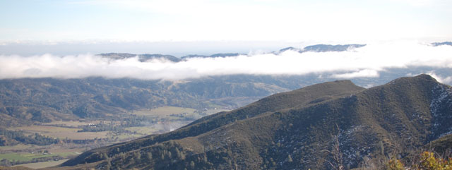
Basics: Sweeping vistas of the Capay Valley, Coastal Ranges, and on a clear day, the Sierras. This hike begins at the Cache Creek Regional Park Lower Site. It is approximately 8 miles roundtrip with an elevation gain of 2300 ft. There is a $6 parking fee – and bring a pen to fill out the little envelope. Dogs on a leash are allowed. Potential hazards include: poison oak, rattlesnakes, and treacherous terrain.
Directions to Trailhead: From Woodland CA, take Route 16 West (also called Main St). Cache Creek Regional Park is on Route 16, approximately 40 miles from Woodland. Once you pass the casino (you can’t miss it), it’s about 15 miles to the park’s Lower Site. Turn left into the parking lot once you see the sign. The hike begins on the dirt road (Road 40) which is on the left side when you drive in.
Trail Description: So after all the holiday gluttony, and the days of cowering indoors thanks to the ridiculously cold temperatures (a high temp of 38-degrees… seriously?!), Rob and I decided to go on our first hike of 2011.
We drove through the fog into the Capay Valley. We drove past the monstrosity that is the casino and made it to the parking lot for the Cache Creek Regional Park (Lower Site).
The hike begins by following the gravel road away from the parking lot towards some K-rail, a gate, and signs that say “Road Closed” and “Bridge Out.” The road continues downwards towards the bridge, which is still standing… for now.

After crossing the bridge, the road continues on a short distance, then U-turns up to the left. Follow this turn and stay on the road until you see the signs for the Blue Ridge Trail.

From here the trail begins climbing, slowly at first. We passed through damp forest with mushrooms under every tree. Rob pointed out some white mushrooms that could have either been some delicious/healthful variety or something called the Destroying Angel – we weren’t going to find out which. We also began hitting some patches of snow.

The trail continued climbing and soon we found ourselves walking amongst chamise. That was a new word for me and I kept calling them chimay bushes and picturing bottles of beer.
Before long the trail opened up to some nice views, especially with the fog clearing.

It’s pretty easy to follow this trail– once you’re on it, there aren’t any forks or side trails to get lost on. It just continues steeply up towards Blue Ridge. There are markers along the side of the trail at 1500, 2000 and 2500-ft. The second half of the trail hits several switchbacks. There’s also one spot where the trail climbs up and around a small landslide. Watch your footing in this area. Come to think of it, this entire trail has some spots that are narrow and steep – this is probably not a trail for people with a fear of heights.


Eventually we reached the ridge. There’s a small use trail leading to a hilltop on the right. Continue towards the left, along the ridge to get to the top of Fiske Peak! We hit a good deal of snow and slippery mud on the trail, but the views along the ridge were well worth it. An elevation marker and a USGS benchmark are at the top of the peak. If it’s not too windy or hot, this is a great (but exposed) place to eat lunch. If it’s a clear winter day like it was for us, you’ll be able to see the Sutter Buttes, the Sierras, Mt. St. Helena and a big snowy peak in the distance that I think may have been Shasta (is that possible?).


The hike back to the car was fast (all downhill) but somewhat brutal on our legs. This is a steep hike, but it’s great for a cold winter day, even if there is a little bit of snow on the trail.

