Nordhoff Peak via the Gridley Trail

20130224-220405.jpg

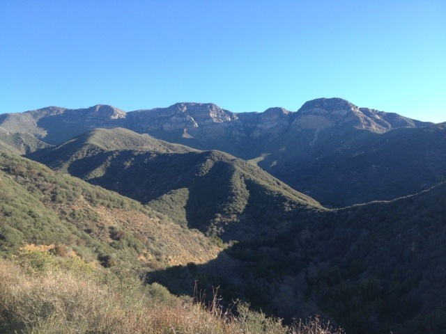
Basics: This 13.8 mile round trip hike climbs 3000-ish feet from the Ojai “guacamole wilderness” to the top of one of the area’s most prominent peaks. There is a skeleton of an old fire lookout at the top. It’s a great climb – views to Reyes Peak, Topatopa and out towards the Channel Islands. This is a popular trail with hikers and mountain bikers, but on a clear blue Sunday in February, it did not feel like it was overrun with crowds. Continue reading “Nordhoff Peak via the Gridley Trail”

Peak 4864

Peak 4864 is the highest point in the Santa Ynez range (the range of peaks closest to the coast, from northern Ventura County up to Goleta). So naturally, I decided we should climb it. According to Wikipedia, this is one of the few east-west trending mountain ranges in the U.S. – makes sense since the “west coast” for this part of California is really to the South. Continue reading “Peak 4864”

Topatopa Bluff – Los Padres National Forest

20130120-133540.jpg

Basics: Last week I happened to be driving through the Santa Paula/Ojai area for work. The peaks around here are a nice departure from the flatlands of Davis and Sacramento. After looking at some local trail guides, I quickly set my sights on the Topatopa Bluffs.  The hike to the top is 14+ mile (roundtrip) and follows both dirt roads and single track trails.  The trail climbs over 4000 ft.  Like much of the Southern Los Padres National Forest, it can get kind of ridiculously hot in the summer, making this an ideal winter hike. Continue reading “Topatopa Bluff – Los Padres National Forest”

Mount Olympia and North Peak – Diablo SP

Basics: This 10+ mile hike takes you up 3000 feet to the top of both Mt Olympia and North Peak in Mount Diablo State Park. The network of trails ranges from wide fire roads to steep and narrow single track footpaths. This trip provides excellent views and makes for a great winter hike. The trail can be accessed at the end of Regency Drive in the town of Clayton – parking at this locations is free. The trail can also be reached from Mitchell Canyon Interpretive Center – parking is $6 and this option adds a mile or two to the trip. A good map of the park is essential. Trail maps can be purchased at the Mitchell Canyon visitor’s center or at REI. Continue reading “Mount Olympia and North Peak – Diablo SP”

Double Dipsea Hike

Basics: The Dipsea Trail is a 7 mile trail running from Mill Valley through Muir Woods and Mt Tamalpais State Park all the way to Stinson Beach.  It is home to one of the oldest trail races in the country – the Dipsea Race – first run in 1905.  With two cars (or a willingness to research bus schedules), the trail can be hiked one way.  If transportation options are limited, it’s possible to hike the entire trail out and back for a total of 14 miles and 4400-ft of elevation gain. Continue reading “Double Dipsea Hike”

Mount Diablo – Summit Hike

Basics: This is a 14 mile hike to the top of Mt Diablo from Mitchell Canyon (on the northern side of the mountain).  There are many trails and many different options for hiking to the top, but all of them will require over 3000 ft of climbing.  Our particular route also took us to the top of Eagle Peak (elev 2369′).  Two peaks in one long hike!  The trail begins at Mitchell Canyon Interpretive Center – located at the end of Mitchell Canyon Road in the city of Clayton.  Parking is $6. Continue reading “Mount Diablo – Summit Hike”

Mount Saint Helens

Basics: This is a challenging winter climb to the summit of an active volcano in the Cascade Range.  The weather is unpredictable, but on a clear day the views are well worth the effort.  The hike from this particular route is approximately 12 miles roundtrip with an elevation gain of over 5700 feet.  There is one other trail (with less elevation gain) to the summit, but it can only be accessed when the road to Climber’s Bivouac is free of snow.  Parking is free but permits are required anywhere above 4800 ft. Continue reading “Mount Saint Helens”

Mount Saint Helena

This is a hike to the highest peak (4339 ft) in Sonoma County, though it’s only about 1500 ft or so away from the Napa County line. The hike is 10.2 miles roundtrip, with an elevation gain for around 2300 ft.

In honor of Robert Louis Stevenson’s 160th birthday today, we are proud to present the first post ever on our blog.  This trail is located in Stevenson’s own California State Park, where he lived in a cabin and wrote The Silverado Squatters.

Summary: This is a hike to the highest peak (4339 ft) in Sonoma County, though it’s only about 1500 ft or so away from the Napa County line.  This trail follows a gently graded fire road, so in cool weather it’s fairly easy despite the distance.  The hike is 10.2 miles roundtrip, with an elevation gain for around 2300 ft.  Parking is free on the side of the road.

Continue reading “Mount Saint Helena”