Sespe Wilderness Loop

The Gene Marshall – Piedra Blanca National Recreation Trail, Johnston Ridge and the Sespe River Trail

It’s been about 6 years since we lived near the southern Los Padres National Forest. We were overdue for a vacation, so we decided to take a few days off work and pay a visit to one of our favorite hiking destinations: the Sespe Wilderness. The trail was pretty rough – not sure this was the most relaxing vacation – but it was good to get out. Continue reading “Sespe Wilderness Loop”

Sykes Hot Springs

The shortest route to Sykes Hot Springs is a 10 mile trek along the Pine Ridge Trail. The springs are deep in the Ventana Wilderness, but a visit to Sykes is not much of a wilderness experience at all. On any given weekend, dozens (if not hundreds) of people are out on this trail with Sykes as their destination. Continue reading “Sykes Hot Springs”

Hines Peak from Middle Lion

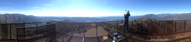
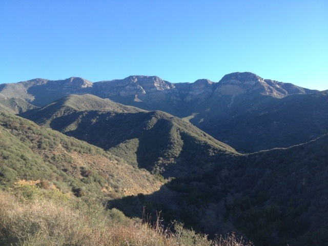
Basics: Hines Peak from Lion Canyon is about 20 miles round trip.  It’s a long hike, but the views from the top of this peak are epic and worth the crazy hike.  Hines Peak is the highest point in the Topatopa Range.  Do not attempt this hike on a hot summer day – the Los Padres can be brutal.

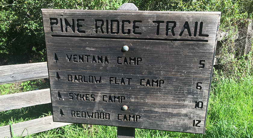
There are at least four different approaches to climbing Hines Peak. The easiest?  Contact the Forest Service to get the gate code for the dirt road leaving Rose Valley, then drive to the end of Nordhoff Ridge Road (4wd required) and begin the hike from there.  The easy hike is around 7 miles roundtrip.  Alternatively, Hines Peak can be reached from Sisar Canyon (20 miles round trip), Middle Lion (20 miles round trip) , Rose Valley (20 miles round trip), or from the Sespe River trail (multi-day trip).  We opted for the 20 mile hike from Middle Lion Campground.  Sisar Canyon seems to be the most common approach – the Sierra Club HPS page has a pretty good description. Continue reading “Hines Peak from Middle Lion”

Backpacking Sespe Hot Springs

Basics: Sespe Hot Springs is located deep in the Sespe Wilderness. There are three possible access points for reaching the springs, but all require either a ridiculously difficult day hike or a strenuous multi-day trip. The Ojai Ranger District has a useful PDF describing the various trails.  We chose to hike from Piedra Blanca (Rose Valley).  Some of the other access points are only open seasonally.  From Rose Valley, it’s a 16 mile trek to the hot springs.  The best time to visit the area is in the late fall, winter, or early spring, though after a large rainstorm, the multiple creek crossings could be difficult.  Summer can be crazy hot in this area.  Sespe Creek has some great swimming holes, but a 16 mile trek to the hot springs might be a bit much when it’s 100 degrees outside. Continue reading “Backpacking Sespe Hot Springs”

Chief Peak from Horn Canyon

Basics: Chief Peak is one of the pointiest summits looming above the Ojai Valley. At 5560 ft, it’s also the fourth tallest mountain in the Topatopa range. The majority of visitors hike this peak from Rose Valley – 9 miles round trip. Alternatively, it’s possible to hike a strenuous 15 miles round trip from Horn Canyon in Ojai. Once atop the narrow summit, you will be rewarded with impressive 360 degree views. This hike is steep, sunny (hot on many days), and uncrowded. Continue reading “Chief Peak from Horn Canyon”

Sespe River Trail to Willett Hot Springs

Basics: This scenic 20+ mile (roundtrip) hike follows Sespe Creek through one of Southern California’s most interesting and rugged wilderness areas. At the end of this long hike is a 100-degree hot spring- great for soaking in after the trek. There are numerous campsites near Willett Hot Springs. There are also many great camping opportunities along Sespe Creek – making this an ideal backpacking trip for anyone who is unsure about how far they feel like hiking. This wilderness is great in spring, summer or late fall. Summer is hot, but may be okay as long as the Sespe still has water in it. Continue reading “Sespe River Trail to Willett Hot Springs”

Nordhoff Peak via the Gridley Trail

20130224-220405.jpg

Basics: This 13.8 mile round trip hike climbs 3000-ish feet from the Ojai “guacamole wilderness” to the top of one of the area’s most prominent peaks. There is a skeleton of an old fire lookout at the top. It’s a great climb – views to Reyes Peak, Topatopa and out towards the Channel Islands. This is a popular trail with hikers and mountain bikers, but on a clear blue Sunday in February, it did not feel like it was overrun with crowds. Continue reading “Nordhoff Peak via the Gridley Trail”

Peak 4864

Peak 4864 is the highest point in the Santa Ynez range (the range of peaks closest to the coast, from northern Ventura County up to Goleta). So naturally, I decided we should climb it. According to Wikipedia, this is one of the few east-west trending mountain ranges in the U.S. – makes sense since the “west coast” for this part of California is really to the South. Continue reading “Peak 4864”

Topatopa Bluff – Los Padres National Forest

20130120-133540.jpg

Basics: Last week I happened to be driving through the Santa Paula/Ojai area for work. The peaks around here are a nice departure from the flatlands of Davis and Sacramento. After looking at some local trail guides, I quickly set my sights on the Topatopa Bluffs.  The hike to the top is 14+ mile (roundtrip) and follows both dirt roads and single track trails.  The trail climbs over 4000 ft.  Like much of the Southern Los Padres National Forest, it can get kind of ridiculously hot in the summer, making this an ideal winter hike. Continue reading “Topatopa Bluff – Los Padres National Forest”