Mt Tamalpais via the Steep Ravine Trail

If you wanted to, you could drive almost to the top of Mt. Tamalpias. But if you want to really climb Mt. Tam, then start from the ocean. This hike leaves from Stinson Beach and climbs the Steep Ravine trail up to East Peak, then loops back on the north side. The grand total is over 16 miles, and a few thousand feet of elevation gain.

00

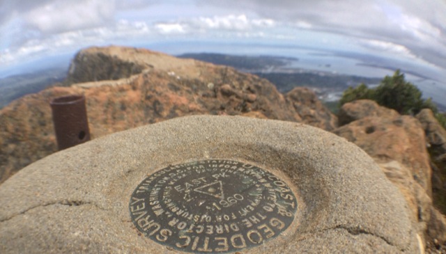
Basics:  This hike climbs from Stinson Beach to the East Peak of Mt Tamalpais.  It’s a long one – we hiked it as a loop totaling over 16 miles round trip.  We reached the top via the Steep Ravine Trail, Matt Davis Trail and Old Railroad Grade road.  We returned on the International Trail, Northside Trail, Bay Area Ridge Trail and Matt Davis Trail (among others).  Mt Tam has an amazingly large and well developed network of trails and roads.  There are many options.  Everything is well-signed, but unless you know where you are going, bring a map! Continue reading “Mt Tamalpais via the Steep Ravine Trail”

Black Butte

Black Butte is a hike up a small volcanic peak with great views of Mt. Shasta. It’s a little over 5 miles round trip and 1850 feet of elevation gain.

00

We drove up to Bend, Oregon last week to visit family and spend a few days skiing.  Not much snow in California this winter, so Mount Bachelor was worth the long trek!  On our drive up, we passed under the shadow of Black Butte – a prominent peak right next to I-5 in the Mount Shasta area.  It looks relatively small next to Mount Shasta, but it is actually 6334-ft and looms steeply above the freeway.  As we drove toward it, we both exclaimed: “What is that peak?  Can we climb it?!”  Turns out, there’s an easy trail that goes to the top. Continue reading “Black Butte”

Hiking the Sutter Buttes (North Butte Ascent)

This hike must be guided by the Sutter Buttes Regional Land Trust. The route goes straight up the butte without any real switchbacks – 1200 feet of elevation gain in under three miles round trip, with the most strenuous part 1000 feet up in half a mile.

00

Basics: Access to the Sutter Buttes is extremely limited. Much of the land is comprised of privately owned ranches. The Sutter Buttes Regional Land Trust (formerly the Middle Mountain Foundation) provides guided hikes into the area. This is really the only way for the general public to access the Sutter Buttes. After looking at the scheduled hikes, I naturally picked one of the most difficult ones: the North Butte Summit Ascent.

The hike itself is not actually that long – about 3 miles roundtrip from the parking area to the summit and back. We added an extra mile or two by taking a detour on the way out. It’s difficult because there is no actual trail. The route climbs over 1000-ft at a very steep grade. Despite the short distance, this hike took at least 5 hours. Continue reading “Hiking the Sutter Buttes (North Butte Ascent)”

Ohlone Wilderness Trail

The Ohlone Wilderness Trail connects Del Valle Regional Park (just south of Livermore) to Mission Peak Regional Preserve (in Fremont). The trail is 28 miles long with 7,100 feet of elevation gain including Rose Peak and Mission Peak.

Rose Peak, Mission Peak & 28 miles of Trail in Two Days

00

Basics: The Ohlone Wilderness Trail connects Del Valle Regional Park (just south of Livermore) to Mission Peak Regional Preserve (in Fremont). It passes through Ohlone Regional Wilderness and Sunol Regional Wilderness, as well as some land owned by the San Francisco Water District where you’re not allowed to leave the trail. The trail is 28 miles in length, not including short detours to campsites or to the top of Mission Peak. There are many out-and-back options for hiking in this area. A shuttle or other transportation arrangement is required to thru-hike the entire 28 miles. Continue reading “Ohlone Wilderness Trail”

Billy’s Hill & Glascock Mountain

This 10 mile hike is located on BLM land, just across the highway from Cache Creek Regional Park. The hike starts off climbing steeply up to Billy’s Hill. If you continue all the way to Glascock Mountain it’s 10 miles and 3100 feet of elevation gain.

gl00

Basics: This 10 mile hike is located on BLM land, just across the highway from Cache Creek Regional Park. The hike starts off climbing steeply up to Billy’s Hill. After enjoying the views from there, it’s possible to continue on up two ridges (with a few steep sections) all the way over to Glascock Mountain. There is no official trail, but the path follows a combination of use trails, fire breaks and a somewhat overgrown fire road. Continue reading “Billy’s Hill & Glascock Mountain”

Mount Tallac in Desolation Wilderness

00

Basics:  Mount Tallac is a 10 mile hike (out and back) with approximately 3500 ft of elevation gain.  The main trailhead is just a few miles west of South Lake Tahoe, though this peak can also be reached from Gilmore Lake and other areas deeper in Desolation Wilderness.  It’s strenuous, but the incredible views down to Fallen Leaf Lake, Lake Tahoe, and over to Desolation Wilderness make this a very popular hike.  On summer weekends, there can easily be dozens of people on the summit at once.  I would recommend an early start.  Permits for day hikes are self-issued at the trailhead.  For overnight trips, reserve your permit in advance at Recreation.gov. Continue reading “Mount Tallac in Desolation Wilderness”

Shepherd Pass and Mount Tyndall

34_000

Back in 2010 when we hiked the John Muir Trail, we took a one day detour to the base of Mount Tyndall with hopes of climbing it. In the morning, we scrambled about halfway up the North Rib before deciding to turn back. I think we didn’t climb the mountain for several reasons: we didn’t do any research and weren’t sure of the route, we still had many miles yet to go (with limited food), we had no helmets (the rocks were very loose), and it was freezing cold which gave us a late start on the climb.  Perhaps I’m just making excuses, but it just didn’t seem like a good idea at the time.  Unfortunately, our failure to summit bothered us until we finally decided to return and finish what we started. Continue reading “Shepherd Pass and Mount Tyndall”

Hines Peak from Middle Lion

Basics: Hines Peak from Lion Canyon is about 20 miles round trip.  It’s a long hike, but the views from the top of this peak are epic and worth the crazy hike.  Hines Peak is the highest point in the Topatopa Range.  Do not attempt this hike on a hot summer day – the Los Padres can be brutal.

There are at least four different approaches to climbing Hines Peak. The easiest?  Contact the Forest Service to get the gate code for the dirt road leaving Rose Valley, then drive to the end of Nordhoff Ridge Road (4wd required) and begin the hike from there.  The easy hike is around 7 miles roundtrip.  Alternatively, Hines Peak can be reached from Sisar Canyon (20 miles round trip), Middle Lion (20 miles round trip) , Rose Valley (20 miles round trip), or from the Sespe River trail (multi-day trip).  We opted for the 20 mile hike from Middle Lion Campground.  Sisar Canyon seems to be the most common approach – the Sierra Club HPS page has a pretty good description. Continue reading “Hines Peak from Middle Lion”

Chief Peak from Horn Canyon

Basics: Chief Peak is one of the pointiest summits looming above the Ojai Valley. At 5560 ft, it’s also the fourth tallest mountain in the Topatopa range. The majority of visitors hike this peak from Rose Valley – 9 miles round trip. Alternatively, it’s possible to hike a strenuous 15 miles round trip from Horn Canyon in Ojai. Once atop the narrow summit, you will be rewarded with impressive 360 degree views. This hike is steep, sunny (hot on many days), and uncrowded. Continue reading “Chief Peak from Horn Canyon”

Castle Peak – Tahoe National Forest

Basics: Castle Peak (9104′) is a prominent mountain close to Donner Pass on I-80. It’s a popular destination for summer hiking and winter snowshoeing or backcountry skiing. The summit is about 3 miles (and 1800′) from the trailhead. In the winter, much of the trail is well graded and easy to follow. The last half mile or so up to the summit is pretty steep. Most people we saw were using snowshoes, but if conditions were really icy, crampons and an ice axe might be a bit easier. Continue reading “Castle Peak – Tahoe National Forest”